
THE LIVING PAST: AŞIKLI HÖYÜK
MİHRİBAN ÖZBAŞARAN – GÜNEŞ DURU – DİDEM TEKSÖZ – SİNAN OMACAN
in memory of UFUK ESİN
INTRODUCTION
One of the enduring outcomes of the transformation that began in the late 1960s with the challenge to traditional archaeological thought has been the questioning of archaeology’s purpose and the audiences it serves. In response to critiques of the positivist methodology and interpretive framework that became dominant during the 1970s, new approaches emerged that brought archaeology into dialogue with disciplines such as ethnology, ethnography, sociology, and experimental archaeology. During the 1980s, the introduction of concepts and approaches including interpretive archaeology, social archaeology, living archaeology, and multivocality further expanded the field. As a result, archaeology has moved beyond the narrow conception of being merely the science of excavation.
The direct or indirect involvement of different segments of society in transforming archaeological data into knowledge has fostered greater interaction and integration, leading archaeological projects to encompass a wide range of activities in addition to excavation. These include the conservation of archaeological sites, the in situ or nearby presentation of excavated remains, the reconstruction of past lifeways, and the transmission of archaeological knowledge to future generations. Such objectives are realized through diverse forms of public engagement, including archaeological parks, open-air museums, and virtual museums.1.

The objectives of the new project initiated after more than a decade of archaeological research at Aşıklı Höyük were shaped by these developments. One of the principal ways in which knowledge generated through excavation contributes to regional history and the shared heritage of humanity is through the conservation, interpretation, and presentation of the archaeological remains. The conservation and presentation project, which has constituted a major component of the work at Aşıklı Höyük over the past four years, has focused on preserving and communicating humanity’s common past through the exceptionally well-preserved example of Aşıklı Höyük, making it accessible not only to the archaeological community but also to wider audiences, while ensuring that the region’s earliest known settlement is transmitted to future generations.
The project’s primary objective is to introduce local communities to the people who inhabited the same landscape thousands of years before them—communities that lived in harmony with nature and with one another, unconstrained by modern notions of nation, race, or ethnic identity. In doing so, it seeks to foster an awareness that the cultural achievements of every historical period possess universal value and that meaningful connections exist between past and present societies. Equally important is the involvement of diverse stakeholder groups in the process of knowledge production, thereby promoting broader public awareness of prehistoric cultures. Another major objective is to encourage the recognition of archaeological and natural heritage as invaluable cultural assets belonging to the region.
The project also aims to expand the existing cultural tourism of Cappadocia by incorporating a site dating back approximately 10,000 years, thereby emphasizing that history extends far beyond the conventional boundaries of written history and the recent past. At the same time, it seeks to stimulate the local economy and, beyond the physical conservation of the archaeological remains, foster a sense of local stewardship, encouraging the community to value, protect, and preserve the site as part of its own cultural heritage.
The First Village Settlement: Aşıklı
Western Cappadocia, with its abundant volcanic raw material resources and diverse ecological niches, offered an exceptionally rich environment for human habitation. Around 10,000 years ago, it became home to the Aşıklı community, among the first sedentary populations in the region to abandon a mobile hunter-gatherer lifestyle. Settling along the banks of the Melendiz River, the inhabitants of Aşıklı occupied the site for approximately one thousand years before abandoning it toward the end of the eighth millennium BCE for reasons that remain unknown.
The adoption of sedentary life by the region’s earliest inhabitants initiated a series of innovations that fundamentally transformed human history. Aşıklı Höyük occupies a pivotal place in prehistory as one of the earliest known settlements associated with the beginnings of agriculture, the first experiments in animal domestication, early metallurgy, and some of the oldest examples of the Anatolian architectural tradition.
According to more than eighty radiocarbon determinations, Aşıklı Höyük dates to approximately 8200–7500 cal BCE. Since the earliest settlement layers have not yet been excavated, it is currently assumed that hunter-gatherer communities abandoned their mobile way of life and settled at the site of Aşıklı Höyük during the first half of the ninth millennium BCE. The volcanic landscape offered an exceptionally attractive environment, providing abundant raw materials such as obsidian, basalt, andesite, and tuff, together with a mosaic of ecological niches including steppe vegetation, fertile plains, narrow valleys, and mountain slopes rich in diverse flora and fauna.
Within this setting, the inhabitants of Aşıklı established settlements comparable in form to present-day rural villages. Although they retained many hunter-gatherer traditions, they also cultivated cereals and legumes and managed herds of small livestock within designated areas of the settlement. These developments, regarded as the earliest stages of animal domestication, together with many other innovations, reflect a profound transition from a way of life that had persisted for millions of years. The architectural remains provide exceptional evidence for the history of architecture, particularly regarding mudbrick construction techniques, building traditions, and the origins of Central Anatolian domestic architecture during the ninth and eighth millennia BCE. Although Aşıklı Höyük shares certain characteristics with Pre-Pottery Neolithic (PPN) settlements known from the Eastern Mediterranean coast, southeastern Anatolia, northern Syria, Iraq, the Zagros Mountains, and other parts of Southwest Asia, it also displays significant differences. In a region traditionally characterized by stone-built architecture, Aşıklı stands out for its remarkably sophisticated mudbrick construction (Duru 2002: 172).
In terms of settlement organization, Aşıklı Höyük represents the earliest known example of the characteristic Neolithic settlement pattern of Central Anatolia. Buildings are arranged in compact clusters, tightly grouped side by side and separated by narrow alleyways (Fig. 1). In addition to these passages, the settlement contains open spaces that functioned either as circulation areas or as refuse dumps and activity zones (Esin 1996). Some alleyways remained open during particular building phases, while others were deliberately blocked by walls in later phases. Excavations have identified three large communal refuse and activity areas. The extremely narrow spaces between adjacent buildings—too narrow for a person to pass through—have yielded deposits that provide important evidence for the construction and use of rooftops, discussed below.
The buildings excavated in the northern sector of the mound are remarkably similar in both plan and size (Fig. 2). They also display comparable construction histories, reflecting structural continuity through repeated rebuilding, as well as similar internal architectural features. When these characteristics are evaluated together with the distribution and density of artifacts, faunal remains, and obsidian tools recovered from the buildings and their associated open spaces, it becomes clear that these structures functioned as domestic dwellings used for everyday life. Although not present in every building, subfloor burials have been identified in a number of these mudbrick houses. None of the buildings contains an exterior doorway below approximately one metre above floor level, suggesting that access was gained through roof openings using wooden ladders. The rooftops therefore constituted an important secondary living space for the inhabitants of Aşıklı.
This residential quarter extends southward as far as a gravel road running northwest–southeast across the settlement. The buildings located south of this road differ markedly from the domestic structures in their location, dimensions, and layout, and they exhibit distinctive wall and floor treatments. The structure known as HV, for example, has a northern wall built in dry-stone masonry. Immediately to its north lies a series of small cellular rooms bounded by a substantial wall composed of five adjacent mudbrick blocks (Esin 1996: Fig. 7). South of the stone wall, the central space—interpreted as an inner courtyard—is paved with large mudbrick blocks, while its walls are plastered and painted red. Further south, the associated T Building is another exceptional structure, distinguished by its nearly square plan, massive walls, lime-plastered floor, red-painted walls and floors, internal features such as channels and benches, and an adjoining open space to the east (Esin and Harmankaya 2007: Figs. 13–14). Considered together with the associated archaeological evidence, these distinctive architectural characteristics suggest that this part of the settlement contained communal buildings serving special functions related to the community’s ritual or ceremonial practices.
In summary, the extensive excavations at Aşıklı Höyük provide invaluable evidence for understanding the architecture of the Central Anatolian Neolithic during the ninth and eighth millennia BCE. The honeycomb-like settlement layout, mudbrick domestic architecture, and the continuity of use observed in both buildings and open spaces are features that also characterize other Neolithic settlements in Central Anatolia. These characteristics, which may collectively be described as the Central Anatolian Neolithic Settlement Model, can be traced chronologically from Aşıklı to later sites, including Can Hasan III (eighth–seventh millennium BCE), Çatalhöyük and Erbaba (seventh millennium BCE), and Can Hasan I (seventh–sixth millennium BCE). Significantly, however, none of these later settlements has yielded the kind of communal public or special-purpose buildings identified at Aşıklı Höyük.²
Development of the Conservation and Presentation Project
Following its discovery in 1963 and two years of initial investigations (Todd 1980), Aşıklı Höyük remained largely neglected for more than two decades. In 1989, archaeological excavations were initiated under the direction of Prof. Dr. Ufuk Esin, then Chair of the Department of Prehistory at Istanbul University. These excavations were conducted as a salvage excavation. Accordingly, the excavation strategy focused on understanding the site’s stratigraphy through two deep sounding areas—one in the north and the other in the northwest—while extensive excavation areas measuring 10 × 20 m were opened across the mound to investigate the settlement layout (Fig. 1). By 2000, the excavated area on the mound had reached approximately 6,000 m², exceeding 6,300 m² when the surrounding slopes and peripheral areas were included.
In 2000, Prof. Esin transferred the directorship of the excavations to Nur Balkan Atlı, also of the Department of Prehistory at Istanbul University. Under Balkan Atlı’s direction, fieldwork concentrated exclusively on the deep sounding designated 4GH, with the objective of investigating the earliest occupation levels of the mound. After a temporary suspension of fieldwork to allow for the evaluation and publication of excavation results, excavations resumed in 2006. At that stage, the conservation of the exposed architectural remains was identified as the project’s highest priority. Although the lower archaeological deposits continued to face the potential threat of inundation from the nearby reservoir, changing regional conditions—including population growth, increased demand for water resources and irrigation, and altered rainfall patterns—paradoxically created more favorable circumstances for the long-term preservation of Aşıklı Höyük and the implementation of a comprehensive conservation program.
Site Conservation Plan
The conservation and presentation project began with extensive discussions concerning what should be preserved, how it should be conserved, and how the archaeological remains should be presented to the public. Integrating the site into the region’s cultural tourism network required careful planning of visitor access alongside the renewed excavation program, as well as the resolution of administrative and bureaucratic issues, financial planning, and the formation of a multidisciplinary professional team capable of implementing the project.
Taking these factors into account, it was decided in 2006 to initiate the project through the preparation of the Aşıklı Höyük Site Conservation Plan, which would provide an integrated framework coordinating conservation, planning, and implementation.
The Site Conservation Plan was developed through close collaboration between the excavation team and Atölye Mimarlık, an architectural practice with extensive experience in the management, conservation, and presentation of archaeological sites. The plan was conceived to ensure that, over the medium and long term, archaeological research could continue while the site would simultaneously be presented to visitors in a clear and accessible manner and its archaeological remains effectively protected. Rather than implementing all interventions at once, the plan proposed a phased strategy, to be carried out progressively as financial resources became available. It was also designed as a flexible framework, subject to periodic revision in response to new archaeological discoveries and evolving research priorities.
The Aşıklı Höyük Site Conservation Plan serves as the comprehensive framework for a series of interconnected projects—including protective shelters, visitor and security facilities, and the Prehistoric Aşıklı Village—ensuring that they are designed, coordinated, and implemented in a consistent and controlled manner. The initiatives developed under the plan are organized under two principal components: Conservation and Visitor Access and Presentation.
Conservation
The first stage of the project involved the cleaning of all previously excavated areas across the mound. Following this surface cleaning, each excavation area was temporarily covered with protective geotextile fabric. This measure minimized damage caused by weathering and vegetation over a period of four to five years, providing sufficient time to determine, within the framework of the Site Conservation Plan, the most appropriate long-term conservation strategy for each part of the site.
For conservation purposes, the excavation areas were divided into two categories according to the excavation schedule and conservation strategy. The first category, designated Phase I excavation areas (Fig. 3, marked in red), comprises those areas where archaeological investigations were to continue and which were planned to be permanently protected beneath shelter structures (Fig. 3, outlined in bold red). The second category, designated Phase II excavation areas (Fig. 3, marked in orange), consists of areas to be excavated following completion of the first phase and subsequently protected using a different conservation method (see Reburial Conservation). Areas shown in light green in the northeastern part of the mound were reserved for long-term future excavations, and their conservation and presentation strategies were intentionally left to be determined at a later stage.
The archaeological site is currently enclosed by a perimeter fence. While Aşıklı Höyük itself is designated as a First-Degree Archaeological Site, the surrounding area is protected as a Third-Degree Archaeological Site.
Protective Shelter Structure
During the first phase, it was decided to construct a single protective shelter. The structure was planned over the exceptional architectural remains located within the designated Phase I excavation area, corresponding to excavation grid squares 2–5 N–R. The selection of this location was based entirely on its archaeological significance, as the buildings to be protected beneath the shelter are unparalleled within the Neolithic architecture of Central Anatolia.
The structure, known as the Southern Shelter, was designed to protect these architectural remains from environmental deterioration while simultaneously providing continuous public access to the site.
Like protective shelters constructed at archaeological sites worldwide, the Southern Shelter was conceived to shield the excavation area from adverse weather conditions while providing optimal natural lighting and ventilation for both archaeological work and visitor experience. Its final architectural form was developed in response to both the archaeological remains and the site’s topographical conditions (Figs. 4–5).
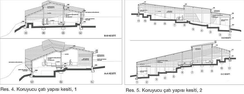
In developing the form of the South Shelter, particular attention was given to emphasizing the plan characteristics of the HV Building, with its central courtyard, and the T Building, distinguished by its lime-plastered floor. To achieve this, natural daylight was enhanced over these structures through the strategic placement of skylights directly above them. Openings in the roof membrane, together with the translucent roofing material, allow natural light to penetrate the shelter and visually accentuate these architecturally significant buildings.
The shelter employs a simple, tent-like roof structure whose geometry follows a series of folds parallel to the natural slope of the terrain. The design carefully minimizes the height of the structure above the mound surface wherever site conditions permit. Consequently, the shelter functions as a landscape element that is clearly distinguishable yet visually subordinate within the archaeological site, harmonizing with both the topography and the natural hillside.
Access to the structure is provided from the gravel road located north of the HV Building, and the overall visitor circulation route has been planned to incorporate this historic pathway. Within the shelter, a timber platform extends through the central courtyard of the architectural complex before gradually descending toward the south. The structural framework of the shelter was designed to preserve the spatial integrity of the fragmented Neolithic architectural remains enclosed within it.
Reburial Conservation
The second phase of the Site Conservation Plan comprises the excavation areas marked in orange on the site plan (Fig. 3), designated as Phase II excavation areas. These are medium-term excavation zones where archaeological investigations will continue before permanent conservation measures are implemented. Occupying approximately 2,000 m² (twenty excavation units measuring 10 × 10 m each), this sector consists primarily of mudbrick domestic buildings and represents one of the most extensive exposures of the characteristic settlement pattern of the Central Anatolian Neolithic.
Upon completion of the archaeological investigations, each excavation trench will be fully documented before being carefully backfilled to ensure the long-term preservation of the original architecture. A durable and clearly distinguishable separation layer will be placed between the archaeological deposits and the clean, screened fill soil, allowing future excavations to differentiate easily between the original deposits and the backfill.
Following reburial, the original ground plans of the buildings are intended to be reconstructed at full scale above the filled trenches using mudbrick. As part of the site’s interpretation strategy, the proposed reconstruction material is alker (gypsum-stabilized mudbrick), a composite of gypsum and mudbrick that retains the appearance of traditional earthen architecture while providing greater resistance to outdoor weather conditions (Acun and Gürdal 2003). A key principle of this approach is reversibility: the alker blocks can be removed and the reconstructed walls dismantled whenever necessary without affecting the preserved archaeological remains beneath. Implemented progressively, this strategy is intended to present the overall organization of a 10,000-year-old Anatolian mudbrick settlement, illustrating the relationships between houses, streets, and open communal spaces across the extensively excavated area.
Visitor Access, Interpretation, and Presentation
An integral component of the Site Conservation Plan is to ensure that visits to Aşıklı Höyük are both informative and educational while maintaining controlled access to the archaeological site. Appropriate infrastructure is therefore required to facilitate visitor circulation and provide effective interpretation.
The project envisions welcoming visitors at a dedicated entrance facility before they enter the archaeological site. According to the architectural proposal, the entrance courtyard contains the Prehistoric Aşıklı Village, a full-scale reconstruction intended to provide visitors with a tangible understanding of the architectural remains they will encounter on the mound. By presenting a complete, three-dimensional reconstruction of Neolithic buildings before the archaeological tour begins, the installation enables visitors to mentally reconstruct and better interpret the excavated remains.
The entrance courtyard also provides the essential facilities required by both visitors and members of the excavation team. From this point, the visitor route begins along a walking trail that extends around the archaeological site (Fig. 3). Observation terraces are positioned at selected viewpoints, while interpretive information panels explain the site’s archaeological and historical significance at key locations along the route.
Entrance Area
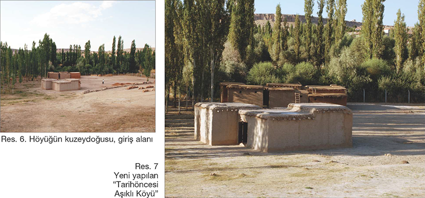
The entrance area serves as the principal point of access for both the excavation team and visitors. Conceived as a transitional space, it welcomes visitors and prepares them for their experience of the archaeological site while simultaneously supporting the daily activities of the excavation team. Immediately beyond the entrance lies the Prehistoric Aşıklı Village, together with the reconstructed Neolithic landscape and entrance courtyard (Fig. 6).
The Prehistoric Aşıklı Village
Located to the northeast of the mound, outside the archaeological site itself, the newly constructed Prehistoric Aşıklı Village recreates a representative group of the Neolithic buildings excavated at Aşıklı Höyük (Fig. 7). Planned within the framework of the Site Conservation Plan and now largely completed, the project was conceived with two principal objectives. The first is to provide archaeologists with an experimental archaeology environment in which questions concerning roof construction, the relationships between buildings at roof level, rainwater and snow drainage, and Neolithic building techniques can be investigated. The second is to create a public interpretation center and open-air museum that offers an alternative and engaging means of communicating archaeological knowledge. Since the experimental archaeology component, with its diverse research questions and methodologies (Mathieu and Meyer 2002: 75–76), merits separate discussion, it will be referred to here only where relevant.
For many years, archaeological reconstructions have been undertaken at sites across Europe and the Eastern Mediterranean, ranging from Anglo-Saxon settlements (Crothers 2008) to Neolithic villages (Dennis et al. 2002). In Türkiye, similar reconstruction projects have become increasingly common in recent years. Two principal approaches have generally been adopted. The first involves the partial or complete reconstruction directly on top of the original archaeological remains; the second recreates excavated structures at a separate location outside the archaeological site. The latter approach has been described in the literature as either an archaeology park or an archaeological park (Colomer 2002). In reconstructions built directly over original remains, accepted conservation principles require that new materials be clearly distinguishable from the original fabric. Within this framework, the Prehistoric Aşıklı Village may be regarded as an archaeological park: an experimental and educational reconstruction of a group of Aşıklı houses built outside the mound using traditional techniques informed by archaeological evidence.
The project reconstructs ten buildings excavated at Aşıklı Höyük, preserving their original plans and dimensions while recreating them in full scale near the archaeological mound.⁶ The interiors have been furnished with reconstructed architectural features and replicas of archaeological finds before being opened to the public. The selected group of buildings was chosen because it most comprehensively represents the domestic quarter of the settlement. Rather than reconstructing a single house, the project recreates an entire neighborhood—including houses, a street, and adjacent open areas used as refuse dumps and activity spaces—thereby conveying the spatial organization of the Neolithic settlement as a whole.
The layout enables visitors to walk along the narrow streets at ground level, experience the compact urban fabric, enter the reconstructed houses, and explore daily life both within the interiors and on the rooftops. In contrast to conventional museum displays, these full-scale reconstructions overcome the difficulty of interpreting archaeological remains that survive only at foundation level. They also eliminate many of the restrictions necessarily imposed within excavation areas, where visitors are generally prohibited from entering sensitive zones or touching original archaeological material. At the Prehistoric Aşıklı Village, visitors are encouraged to engage directly with reconstructed mudbrick walls, plastered surfaces, benches, and obsidian artifacts without the barriers or display cases characteristic of traditional museums.
To recreate aspects of the prehistoric atmosphere, the project also appeals to senses beyond vision. The interiors convey the smell of smoke and soot from hearths after firing, while visitors are offered fruits such as hackberries and almonds, introducing elements of taste as part of the interpretive experience. Located away from modern villages, the reconstructed settlement enjoys an uninterrupted rural setting overlooking the Melendiz River and the volcanic massif of Mount Hasan. Free from contemporary visual and acoustic disturbances, this landscape provides an ideal context for evoking the environmental setting in which the Aşıklı community once lived and for presenting the site as an integrated prehistoric cultural landscape (Fig. 8).⁷
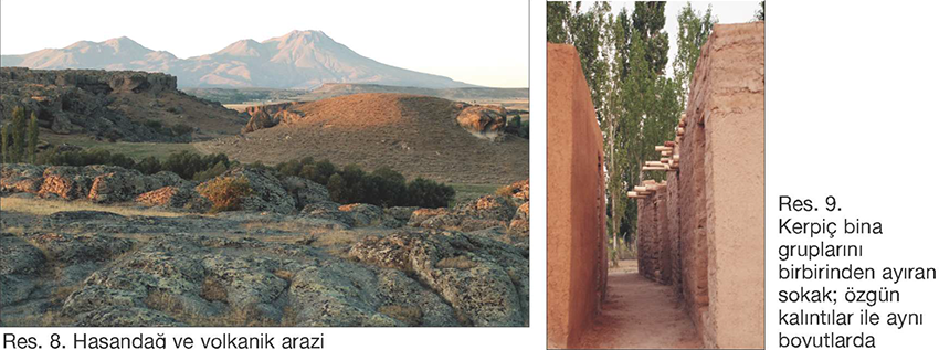
The building reconstructions were carried out during the 2008 and 2009 field seasons and comprise two distinct building groups. During the first season, three buildings excavated in trenches 3J–K were reconstructed. In 2009, a second group consisting of seven buildings, originally uncovered in trenches 5–6J, together with a street and an adjacent open space, was rebuilt (Fig. 9). After the completion of the 2008 buildings, a temporary exhibition installed within them was relocated to the newly reconstructed buildings the following year. With the exception of one structure, the vacated buildings were subsequently adapted to meet the excavation team’s need for enclosed workspaces and equipment storage. As in prehistoric times, the buildings currently in use are maintained annually after the winter season by renewing their exterior mud plaster and repairing the roof coverings. The single-room building left vacant has intentionally been excluded from this maintenance cycle and allowed to deteriorate naturally as part of an experimental study documenting weathering and structural decay.
The construction of the Prehistoric Aşıklı Village was carried out under the supervision of the project team, with the guidance of experienced builders from Kızılkaya Village who had worked extensively with traditional mudbrick construction in the provinces of Konya and Kayseri. The mudbrick mixture⁸ was prepared experimentally by combining earth, water, and straw in carefully determined proportions. After thorough mixing and a resting period, the material was placed into three different molds manufactured according to the dimensions of the original Aşıklı mudbricks. The upper surfaces were then leveled by hand, after which the mudbrick blocks were left to dry. Depending on summer temperatures, the drying period varied between five and eight days. To prevent delays in drying caused by moisture rising from the ground, the bricks were stacked vertically against one another, following the traditional construction practice still used in the region (Fig. 10).
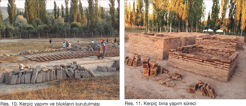
Construction of the buildings began after the ground had been leveled and prepared. Following the marking of the original plans and dimensions onto the ground surface, a thin layer of wet mudbrick soil was spread due to its adhesive/binding properties, and the first course of mudbricks was laid on top of it. In Neolithic Aşıklı houses, there are no stone foundations or foundation trenches; the mudbrick walls were built directly on the earthen ground surface. The mudbrick blocks were laid with mortar prepared from mudbrick soil between them, and the wall surfaces were subsequently plastered (Fig. 11).
Although passageways between rooms existed in multi-room buildings at Neolithic Aşıklı, the buildings had no external entrances. Openings left in the roofs of the newly constructed houses have raised the question of whether access to the houses may originally have been provided from the roof. Since the houses are open to visitors, and considering that entering the houses from the roof using possible Neolithic methods would be difficult and dangerous for visitors, it was decided to create door openings beginning approximately 0.15 m above the ground level. In order to make them inconspicuous at first glance, the doors were constructed of wood, covered with wire mesh, and plastered over with mudbrick soil. In one example, the building was intentionally left without a door; a wooden ladder was placed both inside and outside the structure for visitors wishing to experience a Neolithic-style entrance (Fig. 12).
The walls of Neolithic Aşıklı houses are preserved to an average height of approximately 1 m above the floor level. This is related not only to preservation conditions but also to the building traditions, social practices, and possibly belief systems of the Aşıklı community. After a certain period of use, buildings were renewed (Esin and Harmankaya 2007). Following the removal of roofs and wooden elements, the walls were demolished down to a specific level—approximately 1 m above the floor—and the interior spaces were filled with mudbrick wall debris and leveled. The newly prepared surface then became the floor of the upper building phase, while the earlier walls served as the foundations for the new walls. However, this construction technique prevents the identification of structural characteristics and architectural elements above 1 m.
The main challenge in constructing the reconstructed houses was determining wall heights, roof construction, and roofing systems. Therefore, the wall heights and architectural elements above 1 m in the new houses are hypothetical. It has been indirectly inferred that the houses had flat roofs and that the roof level constituted a second living space for the inhabitants of Aşıklı. In addition to ethnographic parallels, the characteristics of the fills found in narrow spaces between adjacent buildings—spaces too narrow to have functioned as streets or passageways—indicate that these areas were used for the disposal of waste generated by activities carried out on the roof throughout the day. Experimental studies have demonstrated that these gaps could not have been used at ground level and subsequently filled with waste from this level. The fills also provide another important clue confirming that the roof levels of two adjacent Aşıklı buildings were not necessarily at the same height.
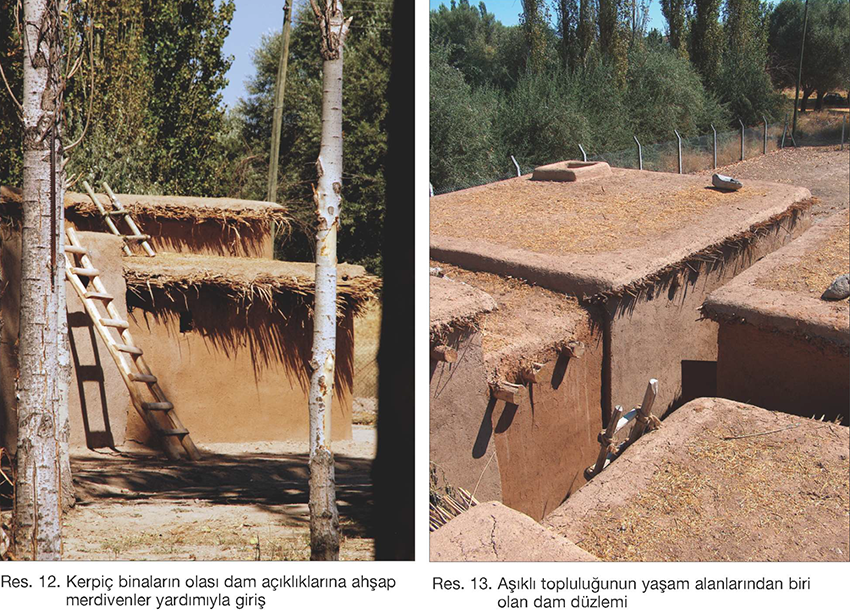
In adjacent Neolithic Aşıklı buildings, differences in floor levels that are occasionally observed were directly reflected in the wall heights and roof structures of the reconstructed houses, thereby creating differences in roof elevations (Fig. 13). The wood and reeds used for roofing were species that existed in the region and were also identified during the Aşıklı excavations. However, no archaeological evidence was found during the excavations regarding the specific types of wood or reeds used in roof construction. Therefore, poplar, the most readily available and economically suitable type of wood in the surrounding area, and reed species growing along the Melendiz River were used in the experimental houses.
After the construction of the buildings was completed and the interior and exterior plastering had been applied, the addition of internal architectural elements and the arrangement of the interiors began. One of the most frequently encountered architectural features in Neolithic Aşıklı houses is the hearth. Since hearths were often left in place during rebuilding phases and have been well preserved on the floors, they are among the elements that could be reconstructed without major difficulty. The plans of the hearths, considered typical of Aşıklı Höyük, are repetitive. They are surrounded by large, flat limestone slabs set vertically, while their bases are paved with river stones (Özbaşaran 1998). They are generally located close to or directly against the southern walls of the rooms in which they are found. In most cases, abundant ash and burnt wood fragments have been observed within them.
Another architectural element associated with hearths consists of small openings thought to have functioned as chimney vents. Five examples of such openings have been uncovered at Neolithic Aşıklı (Fig. 14). These openings, approximately 0.20 m wide, are located in the walls against which the hearths were built. Based on these examples, which functioned as small windows, openings measuring 0.20 × 0.15 m were experimentally placed above the 1 m level of the walls in the reconstructed houses to provide light and ventilation for the interiors. This application is hypothetical (Fig. 15).
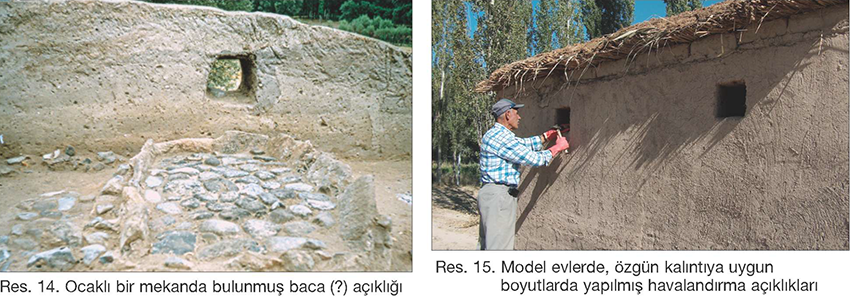
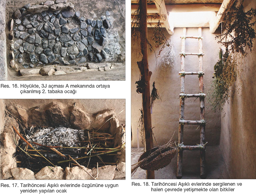
In the newly constructed hearths, the hearth stones removed during excavation were reused (Figs. 16, 17), and hearths of different sizes were displayed in different houses. Particular attention was also given to displaying plant species identified through archaeobotanical studies that still grow naturally in the surrounding area and are currently used as fuel and kindling by the inhabitants of modern-day Kızılkaya village, such as Astragalus (Ertuğ 1997:183). These plants were placed next to the experimental hearths, while the burned wood and brushwood were left on top of the hearths without being removed. The fuel materials, kindling, traces of burning and soot on the walls, together with the smell of smoke, were intended to provide visitors with a sense of daily life inside the houses and create the impression that the buildings had only recently been abandoned.
The same approach was applied to the display of plant remains recovered during excavations (Fig. 18). Hackberry (Celtis) and wild almond (Amygdalus) are among the most abundant species identified at Aşıklı Höyük and are also commonly found today in Kızılkaya Village and its surroundings. These plants and fruits, which attract particular interest from local visitors, provide opportunities for an exchange of knowledge regarding how and when they were used, as well as the similarities and differences between their prehistoric and present-day uses.
Examples of stone tool production and replicas of obsidian cutting and scraping tools were placed alongside the plants. Since all of the displayed tools are copies of original finds, they can be handled, touched, and even used by visitors, allowing for a more direct and interactive experience.
Another form of display inside the houses is the reconstruction of Aşıklı Höyük burial practices. In Neolithic Aşıklı, individuals are known to have been buried in simple pits dug beneath house floors; in some cases, after the burial process, the pit was closed and the floor of the house was renewed. The skeleton displayed within a burial pit opened in the floor is a replica made of plastic, in consideration of cultural sensitivities regarding the display of human remains. It was painted to resemble real bone and placed inside the pit in the same position as those uncovered during excavations: in a contracted fetal position, as if inside the womb (Fig. 19).
The final building along the visitor route through the prehistoric Aşıklı Village houses is dedicated to a video presentation. A short documentary film presenting the archaeological excavations at the mound, the results obtained, and the place and significance of Aşıklı Höyük in human history is shown with English subtitles for visitors who wish to watch it. In the same space, brochures containing a plan of the mound, the visitor walking routes, and brief explanatory information are available for those who would like to visit the Aşıklı Höyük excavation area.
The area extending north and west of the reconstructed houses toward the neighboring plots has been landscaped with trees and plants known to have existed in the region since the Neolithic Period, with the aim of introducing visitors to the vegetation of this period. The Neolithic landscape is still under development.
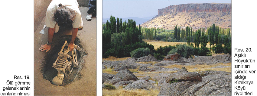
Following the visit to the Prehistoric Aşıklı Village, visitors are directed to the mound tour if they wish. The route allows visitors to see the special-function structures displayed under the protective roof structure, observe excavation activities during the excavation season, and view the three main elements of the Neolithic landscape—Mount Hasan, the Melendiz River, and the Kızılkaya rhyolite formations—from different points on the mound (Fig. 20).
CONCLUSION
It is evident that the approximately 30–40 inhabitants of Kızılkaya Village who have participated directly in the fieldwork at Aşıklı Höyük every excavation season for many years, as well as their families and other members of the Kızılkaya community who have been indirectly involved, have developed an interest in archaeology, culture, and cultural heritage, and have begun to perceive the mound as a part of their own village. Most of the workers, reflecting the economic and social structure of Kızılkaya Village, are elderly people over the age of 50, along with high school students and a small number of university students.
The interest of the elderly in the “past,” and the younger generation’s adoption of the Aşıklı Höyük excavations due to the economic income they obtain for themselves and their families by working during the summer months, have gained a new dimension through the ongoing project. In particular, the Prehistoric Aşıklı Village, functioning as an open-air museum and archaeological park, together with a series of related activities, has been observed to strengthen mutual communication between the excavation team and the local community.
The increase in the number of visitors to Aşıklı Höyük, the interest and visits of local authorities, the road constructed by the Gülağaç District Governorate from Kızılkaya Village to the entrance of the mound, the recognition of Kızılkaya Village through Aşıklı Höyük in national and local newspapers and television channels, the documentary-style informative presentations given twice a month by the excavation team to village residents during the excavation season,⁹ the posters, and especially the Aşıklı Höyük Children’s Archaeology Workshop (Sert 2008) should all be emphasized as important factors contributing to this process.
In conclusion, the project carried out at Aşıklı Höyük between 2006 and 2009 demonstrated, through its community-oriented role, that visitors and local residents could develop and experience an alternative understanding of the relationship between humans, other people, and nature. This relationship differs from the forms traditionally accepted as familiar or ideal. Furthermore, one of the most important contributions of the project for its practitioners has been the development of less descriptive and more analytical approaches (Alcalde Gurt 2002: 52) in the transmission of cultural heritage and in communicating its significance.
ACKNOWLEDGEMENTS
As the Aşıklı Höyük team, we would like to express our gratitude to the General Directorate for Cultural Heritage and Museums of the Ministry of Culture, the Dean’s Office of the Faculty of Letters at Istanbul University, and the Scientific Research Projects Coordination Unit of Istanbul University, which provided financial support for our research (Project Nos. 2092 and 3343), as well as to DÖSİMM, for enabling us to carry out our work since 2006.
At the end of the 2008 excavation season, we unexpectedly received news of financial support from the United States Embassy in Ankara (Project No. STU-150-08-GR-104/B). Thanks to this support, the preparation of the Site Conservation Plan and the project design studies for the protective roof structure could be carried out. We would like to express our deepest gratitude to the officials of the Cultural Affairs Section of the United States Embassy for their valuable contribution.
The Aksaray Governorship, Aksaray Provincial Directorate of Culture, and the Gülağaç District Governorate have shown particular interest in our work, followed our activities closely, and provided continuous support. We sincerely thank these institutions.
We would also like to express our endless gratitude to the Aşıklı Höyük team members, the people of Kızılkaya Village, and especially Mr. Naci Kayan, the caretaker of Aşıklı Höyük, whose extensive knowledge and experience have been invaluable to us in every aspect of our work.
NOTES
1
This development concerns prehistoric archaeology; the emergence of conservation and restoration approaches within the archaeological field, and their first applications, began in the mid-18th century. For detailed information on this subject, see Naycı (2010).
2
This situation may be related to the fact that Aşıklı Höyük is the most extensively excavated settlement among comparable sites. While the excavated area at Aşıklı Höyük exceeds this proportion, at Can Hasan III, Erbaba, and Can Hasan I this ratio remains below 6% (Düring 2006). At Çatalhöyük, however, recent excavation strategies—particularly the excavation of Area 4040—have provided new and important information about settlement organization, open areas, and streets, supplementing the results obtained from the excavations of the 1960s (www.catalhoyuk.com/downloads/Archive_Report_2007.pdf).
3
In 1988, a letter sent from the State Hydraulic Works (DSİ) to Prof. Dr. Ufuk Esin reported that the water level of the Mamasun Dam, constructed on the Melendiz River, would be raised and indicated the possibility that the archaeological deposits of Aşıklı Höyük, up to 10 m above the plain level, could be submerged. Although the mound, which exceeds 16 m in height, would not be completely destroyed and would remain as a peninsula-like formation, the settlement would suffer severe damage due to the mudbrick nature of its architecture; therefore, the initiation of rescue excavations became necessary.
Following this notification, in 1989 Prof. Dr. Esin decided to begin rescue excavations at Aşıklı Höyük with a team composed primarily of students and academic staff from the Department of Prehistory, together with specialists from abroad.
5
Before covering the remains with geotextile material, various other conservation methods were tested. A chemical mudbrick consolidant was applied to selected walls and sections for preservation purposes. The transparent liquid chemical was tested using three different application methods: spraying, brushing, and injection. However, it was observed that this method did not produce the expected results under the environmental conditions of Aşıklı.
6
ICOM Code of Ethics for Museums, 2006. http://icom.museum/ethics.html#section4
7
ICOMOS Charter for the Interpretation and Presentation of Cultural Heritage Sites, 2008. http://www.international.icomos.org/charters/interpretation_e.pdf
8
During excavations at Aşıklı Höyük, eight different types of mudbrick soil were identified. This classification, based on color, texture, and inclusions, was made macroscopically (Dede 1997). Sampling for thin-section studies and chemical analyses was conducted in 2008 and 2009. Since the analyses had not yet been fully completed, the initial results could not be applied to the experimental houses.
In accordance with the analytical results, our studies on a mudbrick building constructed entirely using prehistoric methods and techniques continue within the framework of a TÜBİTAK project (Project No. 109K030), separate from the Aşıklı Village structures mentioned here.
The soil used for mudbrick construction in the Aşıklı Village reconstructions was obtained from mound soil excavated during archaeological excavations. However, although rare, it is known that some Neolithic Aşıklı buildings were constructed using a different reddish-colored soil. Soil with a similar color and texture is located northwest of Kızılkaya Village, within the boundaries of Aşıklı Höyük, immediately beside the modern Aksaray–Ihlara highway and approximately 700 m from the mound. Both types of soil were used in the model houses.
REFERENCES
Acun, S. and E. Gürdal, 2003.
“Yenilenebilir Bir Malzeme: Kerpiç ve Alçılı Kerpiç” [A Renewable Material: Mudbrick and Gypsum-Plastered Mudbrick]. Türkiye Mühendislik Haberleri 427-5: 71–77.
Alcalde Gurt, G. 2002.
“The Interaction of Museums and Archaeological Sites in the Social and Economic Framework of a Territory.” International Seminar on Museology, Display and Presentation of Archaeological Sites in the Mediterranean Countries: 51–53. Museu d’Arqueologia de Catalunya.
Colomer, L. 2002.
“Educational Facilities in Archaeological Reconstructions.” Public Archaeology 2: 85–94.
Crothers, M. E. 2008.
“Experimental Archaeology within the Heritage Industry: Publicity and the Public at West Stow Anglo-Saxon Village.” In P. Cunningham, J. Heeb and R. Paardekooper (eds.), Experiencing Archaeology by Experiment: 37–46. Oxford: Oxbow Books.
Dede, Y. 1997.
Aşıklı Höyük Kerpiç Yapılarının Korunması Üzerine Çalışmalar [Studies on the Conservation of the Mudbrick Structures of Aşıklı Höyük]. Istanbul University (Unpublished MA Thesis).
Dennis, S., B. Finlayson and M. Najjar, 2002.
“Conservation and Presentation of Neolithic Beidha, Southern Jordan.” Antiquity 76: 933–934.
Duru, G. 2002.
“Some Architectural Indications for the Origins of Central Anatolia.” In F. Gérard and L. Thissen (eds.), The Neolithic of Central Anatolia: 171–180. Istanbul: Ege Yayınları.
Düring, B. 2006.
Constructing Communities. Leiden: Nederlands Instituut voor het Nabije Oosten.
Ertuğ, F. 1997.
An Ethnoarchaeological Study of Subsistence and Plant-Gathering in Central Anatolia. 3 vols. Washington University (Unpublished PhD Dissertation).
Esin, U. 1996.
“On Bin Yıl Öncesinde Aşıklı: İç Anadolu’da Bir Yerleşim Modeli” [Aşıklı Ten Thousand Years Ago: A Settlement Model in Central Anatolia]. In Y. Sey (ed.), Tarihten Günümüze Anadolu’da Konut ve Yerleşme: 31–42. Istanbul: Tarih Vakfı Yayınları.
Esin, U. and S. Harmankaya, 2007.
“Aşıklı Höyük.” In M. Özdoğan and N. Başgelen (eds.), Türkiye’de Neolitik Dönem: Yeni Kazılar, Yeni Bulgular [The Neolithic Period in Turkey: New Excavations, New Findings]: 255–272. Istanbul: Arkeoloji ve Sanat Yayınları.
ICOM Code of Ethics for Museums, 2006.
http://icom.museum/ethics.html#section4
ICOMOS Charter for the Interpretation and Presentation of Cultural Heritage Sites, 2008.
http://www.international.icomos.org/charters/interpretation_e.pdf
Mathieu, J. R. and D. A. Meyer, 2002.
“Reconceptualizing Experimental Archaeology.” In J. R. Mathieu (ed.), Experimental Archaeology: 73–82. BAR International Series 1035.
Naycı, N. 2010.
“Arkeolojik Alanlarda Bilimsel Koruma Yaklaşımlarının Kuramsal Gelişimi ve Türkiye’deki Mevcut Durum Üzerine Bir Değerlendirme” [An Evaluation of the Theoretical Development of Scientific Conservation Approaches in Archaeological Sites and the Current Situation in Turkey]. Arkeoidea VIII: 98–143.
Özbaşaran, M. 1998.
“The Heart of a House: The Hearth – Aşıklı Höyük, a Pre-Pottery Neolithic Site in Central Anatolia.” In G. Arsebük, M. J. Mellink and W. Schirmer (eds.), Light on Top of the Black Hill. Studies Presented to Halet Çambel (Karatepe’deki Işık: Halet Çambel’e Sunulan Yazılar): 555–566. Istanbul: Ege Yayınları.
Sert, G. 2008.
“Aşıklı Höyük’te Çocuklara Eğitim” [Education for Children at Aşıklı Höyük]. Bakış – Kültür Sanat Ekonomi Dergisi 3 (November–December): 50–52.
Todd, I. 1980.
The Prehistory of Central Anatolia I: The Neolithic Period. Göteborg: Paul Åström Förlag.
Websites
Aşıklı Höyük Project Website.
www.asiklihoyuk.org
Atölye Mimarlık.
www.atolyemimarlik.com
Çatalhöyük Research Project Archive Report.
www.catalhoyuk.com/downloads/Archive_Report_2007.pdf